
Learn from the past, understand the present, and plan for a better future.
Our urban systems are interwoven with digital infrastructures. Data has become an essential component for modern services, from managing urban mobility to guiding political decision making. This new layer in our cities is mostly invisible, yet its impact can be experienced virtually in every sector of the contemporary city. This exhibition displays work from researchers, urban planners, activists, and artists from around the world who try to visualize this new perspective on our urban environment.
The combination of openly accessible data and meaningful visualisation approaches can lead to more transparency and trust in our cities. Time after time, we witness how visualising open data can be a powerful tool for cities wanting to experiment with new approaches towards urban planning, as well as how open data can help citizens understand the inner workings of their cities. The visualisations shown in this exhibition exemplify the powerful role open data can play in urban settings.
The CityVis 2018 competition presents the best submissions from the CityVis.io platform, as selected by an international program committee. The platform was launched in 2016, when the first exhibition of works was presented at the UN conference Habitat III in Quito, Ecuador. Since then, the project has grown to an international and interdisciplinary platform for knowledge exchange around the topic of urban data visualisation.
 Research
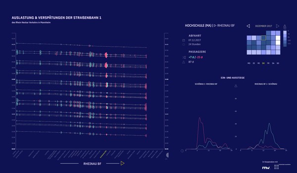
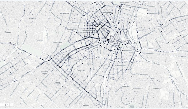
PAXmotion
Mannheim University of Applied Sciences
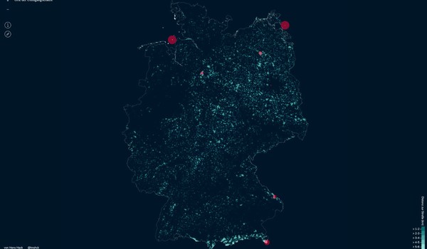
This visualization system is designed to support urban transit planners and policy makers to better understand and explore passenger demands. It visualizes boarding and deboarding passengers as well as deviations from the time plan in order to allow analyzing of possible interplay between these. Thus, the temporal characteristics can be easily seen, for example in the emerging commuting patterns. The project is an interdisciplinary research project developed by students of the Mannheim University of Applied Sciences in cooperation with the Rhein-Neckar-Verkehr GmbH, a public transport company.
Shortlisted
 Jounalistic
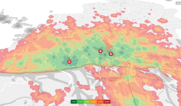
Will taking the train soon take more time?
1) Targomo, 2) SPIEGEL ONLINE
The state of Hamburg is planning to relocate one of its major transport hubs, the train station Altona. Deutsche Bahn and the city are claiming that this will improve accessibility for many citizens. A data-driven analysis by SPIEGEL showed that those claims do not add up. The German news magazine presented the results through multiple maps, showing the difference in accessibility before and after the planned relocation. Furthermore, the impact on citizens living or working near the station was visualized. For the traffic analysis, SPIEGEL teamed up with spatial data experts company Targomo.
Shortlisted
 Art & Advocacy
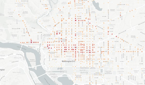
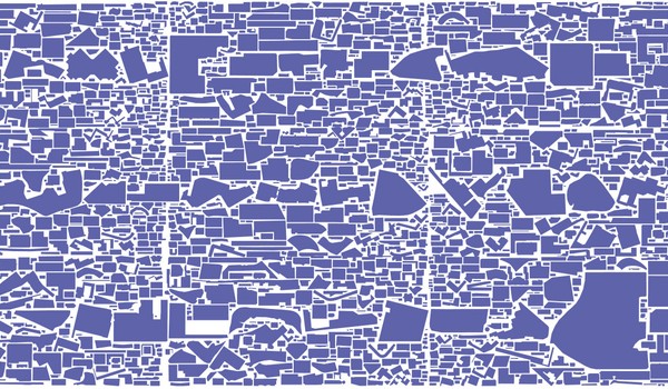
What the Street!?
1) Central European University, 2) Independent
What the Street!? is an open-source online platform that visualizes massive user-generated urban infrastructure data from OpenStreetMap. The platform visually rearranges all parking and mobility spaces of cars, rails, and bicycles of a city to be directly comparable, making mobility space inequality accessible to a broad public. In addition, the project introduces the mobility triangle for comparing modal shares with available mobility spaces, confirming the allocation of a privileged amount of urban space to cars at the expense of more sustainable mobility like cycling.
Shortlisted
 Student
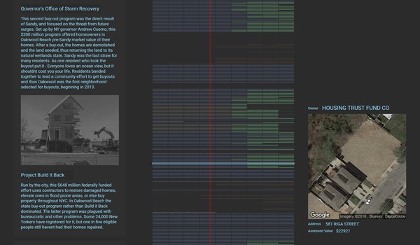
Razing NYC: Buyouts and Demolition in the wake of Hurricane Sandy
Columbia University
This project explores the aftermath of Hurricane Sandy for the town of Oakwood,New York. When the state finally stepped in with a buyout and wetlands reseeding plan, the majority of residents of Oakwood, survivors of Sandy, appreciated the help and were willing to relocate. However, it left some steadfast owners isolated in a fundamentally transformed landscape. This project reveals when and which homes were demolished, and offers many interactive features that reveal hidden patterns in Oakwood's profound transformation.
Shortlisted
 Berlin
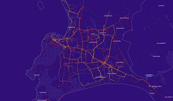
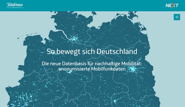
So bewegt sich Deutschland
1) Telefónica Germany NEXT GmbH, 2) Datenfreunde GmbH, 3) arsmedium zwei GmbH
The heart of this project is an interactive map using anonymized mobile phone data to visualize nationwide traffic flows. The aim is to introduce and highlight the benefits of a new data class for sustainable mobility and transport planning in Germany. It provides regional insights on topics such as commuter behavior or morning departure times for Hamburg, Berlin and Munich. Beyond an exploratory tool for users to explore their own city or region, Telefonica provides two deep dives, with one looking at a typical day in Germany and the other providing insight into the carnival celebration as a special event.

Organizers
Chairs
- Sebastian Meier Technologiestiftung Berlin
- Marian Dörk FH Potsdam
Program Committee
This project is a collaboration between the Technologiestiftung Berlin and the University of Applied Sciences Potsdam (FHP). The project selection for the City Vis 2018 exhibition in Berlin is conducted through a review process of an international expert committee. The international program committee consist of experts from visualization research, urban sciences and communication.
- Andrew Hill Textile
- Andrew Van de Moere KU Leuven
- Christina Elmer Spiegel Online
- Daniel Gonzalez Here
- Dare Brawley Columbia University
- Greg McInerny Warwick University
- Hendrik Lehmann Der Tagesspiegel
- Isabel Meirelles OCAD University
- Jan Willem Tulp Tulp Interactive
- Jason Dykes City University London
- Jim Vallandingham Zymergen
- Juan Francisco Saldarriaga Columbia University
- Lio Benz IXDS
- Moritz Stefaner Independent
- Natalia Andrienko Fraunhofer IAIS
- Rodrigo Medeiros Federal Institute of Paraíba
- Sarah Goodwin Monash University
- Sajjad Anwar Development Seed
- Till Nagel University of Applied Sciences Mannheim